History of Sharon and its Environs
History of Sharon and its Environs was written by Adelaide L. Dixon from material collected by Sarah Graham Morrison and J. D. Shatto. The history or narrative of Sharon, Pennsylvania below is necessarily brief and has been adapted from the 1941 Sharon Centennial Celebration program.
Below the accordion is additional historical information from different sources.
-
From roving Seneca to Charles II, to Willaim Penn, and thence to the Commonwealth of Pennsylvania, passed the title of the land on which Sharon now stands. After the Revolution, the west lay open to the pioneer. In the Spring of 1796, William Budd, a Washington County boy of 22, came by canoe up the Beaver and Shenango Rivers, claimed 400 acres of land, built a log cabin, Sharon’s first home, at what is now the northeast corner of Washington Street and South Irvine Avenue. Soon his bride, Drusilla Hultz, shared a new cabin, with puncheon floor and greased paper windows; and in 1798, William Budd, Sr., his wife, and seven children, came to settle the land that the enterprising younger William had pioneered.
The Budds first built on the site of Sharon, but the Bentleys, also of Washington County, had a prior land claim, and from this fact arises a question as to which family is justly entitled to be considered Sharon’s first. However that may be, the Budds were not long alone, for soon came Bentleys, Renos, Stokleys, Hoaglands, McBrides, and Loves, pioneer families all, whose names survive here today, and some descendants are to be found to the seventh generation. The life was hard, but Americans seasoned by a successful war thought little of wilderness trails. The few Cornplanter Seneca Indians who lived along the Shenango were never belligerent, though occasionally a little light-fingered. But the first years were hard, it not dangerous, for the settlement was isolated in a wilderness pierced only by Indian trails, and the nearest church, doctor, and post office were at Pittsburgh, several days’ hard travel away. In spite of hardships, these pioneers came to stay, and May 23, 1798, the first second-generation Sharonite made his appearance in the tiny person of James Bentley, the first white child born here.
-
The coming of the Nineteenth Century brought changes, new counties on the western frontier — among them Mercer — new townships, new settlers, Moores and Hulls, and a weekly mail between Erie and Pittsburgh which brought the post as close as Meadville. Sharon was no longer isolated in those first years of the 1800s.
In 1803, the firsts came fast — the Baptist church, with 19 members in 1804, a post office as near as Mercer in 1805, in 1806, Christian Miles’ tavern, the first in Shenango Township, and in 1807, the first physician in the district, Dr. John Mitcheltree — and the first graveyard, the old Baptist plot on the West Hill, the gift of William Budd.
The year 1808 was a banner one in Sharon’s history, for then, on William Wood’s Tavern license, the name “Sharon” first appears on any record. Tales of its origin abound. The legend of its Biblical source is most generally accepted, but the truth is that no one knows how it first came to be applied to the hamlet. But the origin of the name mattered not at all. The young settlement was enjoying a healthy natural growth, and constantly getting in closer touch with the outside world. Men were finding coal, reading Mercer’s “Western Press”, the second oldest paper west of the Alleghenies, and watching Sharon boys march off to the War of 1812.
When the boys came home, Sharon, founded in the enterprising spirit of true Americanism, had all the necessities for a good American life — churches, medical care, and a school. Best of all, it had the rich resources of spirit that had won these amenities of life and that would insure their survival as the century rolled on. The pioneer days were over, and Sharon, the village, emerged.
-
The chronicler at this point finds it hard to avoid monotonous repetition of the word “first”, for so many things came all at once. In 1818 the first bridge was built over the Shenango, at a cost of $600. Along the new wooden sidewalks went pedestrians, perhaps to Jake Cozadd’s shoe shop, or Elias Jones’ store, or to Jones’ competitors, Quimby or Reno (later changed to Quinby). The travel and shopping were by day. Although mail now came twice a week, by stage instead of on horseback, and there was a new schoolhouse, the Sharonites who made the trip to see General Lafayette at Mercer in 1824, came home to a village whose streets were unlighted, and choked with dust or in deep mud.
By 1825, new names had appeared in Sharon, and new faces in the business houses. “Daddy” Washington Porter kept store at the southeast corner of State and South Water Streets, and Daniel Budd had a new tavern. Sharon was still a log settlement, but it was home to people who had faith in its future, and the courage to make that future bright.
The thirties moved faster. They brought a Methodist Episcopal Church, and agitation for the Erie Canal, with the familiar names of Budd, Porter, Curtis and Trout appearing among the sponsors. They brought Carvers and DeForests. They brought, in 1835, the discovery of splint coal on the Patterson farm, and talk of a railroad. In 1836, General Curtis moved from Mercer to Sharon, to become a great factor in the village’s business life. In 1837, North Main Street was laid out, and two years later, the Curtis coal bank was opened.
“The roaring forties” is a familiar phrase, and the forties were that in Sharon. The opening of its fourth decade saw Sharon with a population of 400. Most of those 400 would line the river bank to see the canal boats go through. The Erie Canal gave the first great impetus to the development of the Shenango Valley. The boats carried loads of Curtis and Boyce’s Sharon coal, and more importantly, they brought here new settlers who saw an expanding future. It took the eyes of pioneer American faith to envision that future, for in the early forties, Sharon was still sprawled out along the Shenango, with only a few scattered stores and dwellings to give it form. Sharon was almost country then, but having proved its stamina for 50 years, Sharon stood on the threshold of its greatest growth, for ahead of it lay the splendid hundred years we celebrate so happily today.
-
Sharon was incorporated as a borough on March 23, 1841, and the next November, M. C. Trout was elected burgess. The names signed to the incorporation petition are a “Who’s Who” of early Sharon. Among them we see Budds, Irvines, Carvers, McClures, Trouts, Pattersons, Hoaglands, Clarkes, Quimbys, Renos and Willsons. The little borough had its full complement of officers, but much unimproved land lay within the limits. Sharon’s strength lay not in city improvements, but in founding fathers who had a firm belief in its future.
The passing years justified that faith. There was a constant growth, slow but dependable. The Canal helped business, and more loads of Curtis coal were shipped. In May 1843, Perry L. Williams brought his April bride from Trumbull County and opened a cobbler shop. It was the forerunner of the Williams’ shoe store, which was to continue for three generations. Sharon was four years old when, in 1845, James. M. Willson, Brookfield lad, stood on the top of the West Hill looking down into the valley, then toward Brookfield Center, trying to decide where to cast his lot. Would it be the flourishing Ohio village, or the smaller Pennsylvania settlement below him on the muddy Shenango? He figured that the new covered bridge, then building, though only a single track affair 20 feet wide, would enable Sharonites to get across the river and beyond city limits, where the overhead was less, and buy chairs from Willson, Logan and Partridge. He cast his lot with Sharon, and from that boy’s decision sprang what is today Sharon’s oldest family business.
The young furniture merchant saw in the next year, 1846, six blast furnaces built in the Shenango Valley. He saw Frank Allen’s experiments at Clay Furnace, and more pertinent to a State Street business man, he saw the laying of a raised log sidewalk that served to connect west and east Sharon, and keep his lady customers’ trailing skirts out of the mud.
-
Old “Squire” Budd died in 1849, on the very eve of a period of amazing growth for Sharon. In 1850 Sharon had 541 people, who were to witness a great boom. The most notable events of that year were the opening of mill where nails were first made, and the incorporation of the first Sharon Iron Company, headed by General Curtis, with a capital stock of $70,000. The Iron Age had begun. In 1851, the rolling mill started, and to accommodate the hardy men who were turning out 45 tons of pig and 150 tons of bloom a week, long rows of company houses were built. In one of them, over 30 years later, there grew up a Welsh immigrant boy, destined to become the first Secretary of Labor, and afterwards Senator from Pennsylvania, James. J. Davis. In 1851 came Henry and William Crosthwaite, natives of Ireland, first settlers of the Catholic faith. The great flood of 1852 was only a temporary setback. The Christian Church was built that year, the Curtis rolling mill was abandoned, and steel furnaces were erected in its place at enormous cost. In 1854 the borough limits were extended for the first time, making Sharpsville Street the eastern boundary. In that same year William McGilvray and Co. built a foundry and machine shop, and W. L. Mordock established the first insurance business. A disastrous fire in 1856 brought about the organization of the Volunteer Fire Department. That same year, Septimus Marsden came from Pittsburgh to superintend the work at the Sharon Iron Company. Frank Allen’s experiments at Clay Furnace were successful that year, and they bore fruit the next, when G. W. Tiffty built the Shenango Furnaces at Sharpsville. New prosperity pulsed through Sharon. It was apparent in the new Presbyterian Church, the new Odd Fellows’ Hall, in the refitting of abandoned furnaces, and in the rapidity with which prosperity changed hands.
-
Sharon’s population almost doubled in the ten years prior to 1860. Nine hundred people lived here in that year. The decade ahead was to hold for them the advent of railroads, telegraph and banks. The business men thought of serious matters and discussed the election of Lincoln, for whom Sharon turned in a large majority. The young folks danced Money Musk and the Virginia Reel, and on gala nights stayed out until twelve. Sharon was becoming quite a metropolis. Brick houses were replacing frame ones. The first train came through Sharon on January 4, 1864, and crowds flocked to the station to see if any local boys were home on furlough from the Civil War. On April 11 of that year appeared the first issue of the “Sharon Herald,” a weekly of four seven-column pages. The proprietors were R. C. and J. C Frey. In that year the cornerstone was laid for Sacred Heart church.
The year 1865 saw the end of the war, and the erection of more than 100 new buildings, among them the $11,000 United Presbyterian Church, the $24,000 Central School building, and, most important for a thriving community, the pioneer bank was established by C. B. Wick, S. Q. Porter and William Coleman. Three years later, in August of 1868, the First National Bank was chartered, and the following month came the Sharon Savings Bank. To care for growing business, the 86 room Shenango House was built, with running water in every room — and pipes for gas, if and when!
-
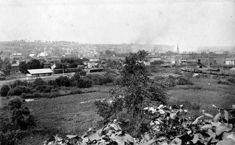
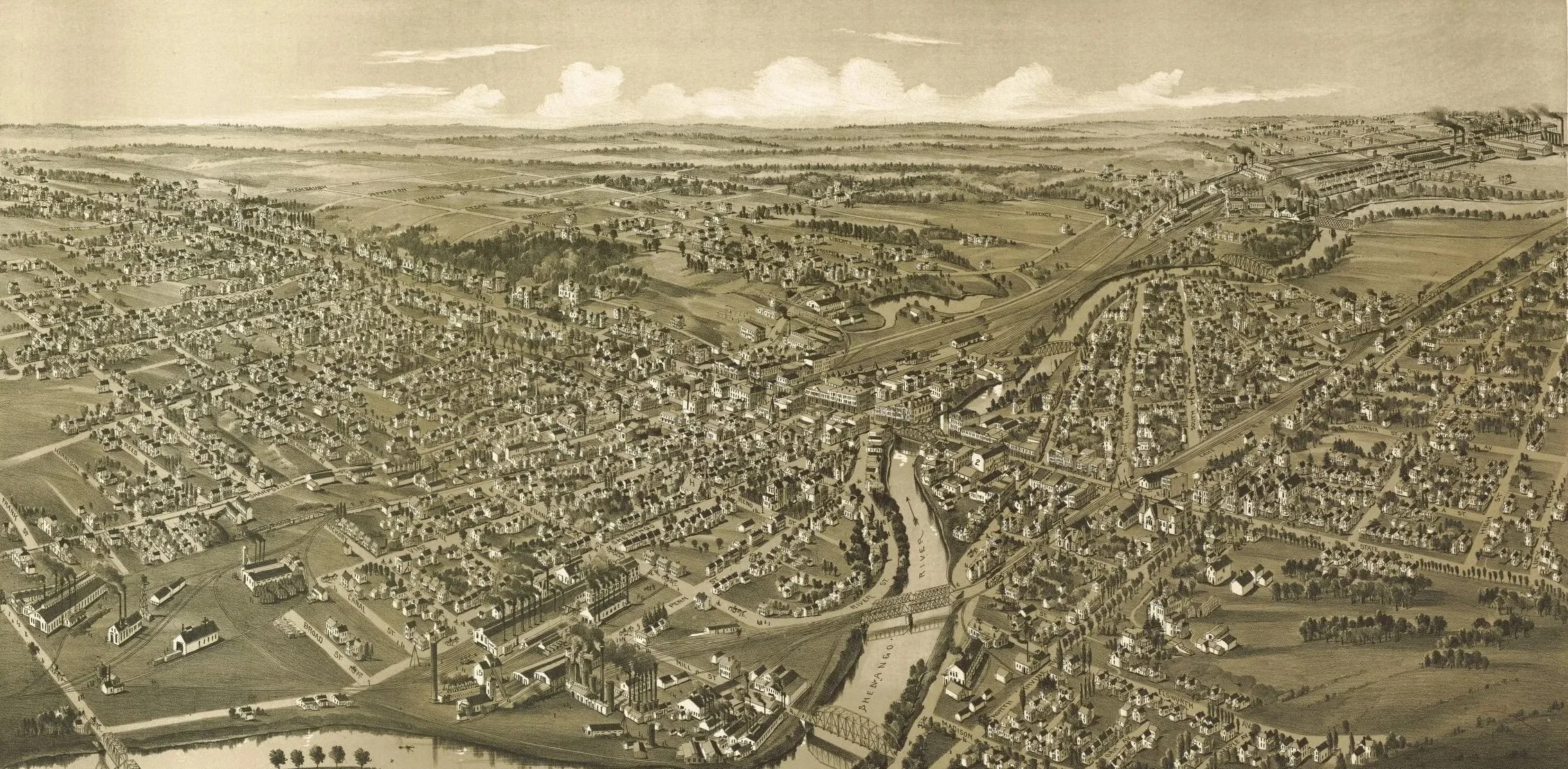
The year 1870 is a real milestone. Sharon’s population was 4,221. It had outstripped Greenville and Mercer, and taken its place as the largest town in the county. In 1870, too, James Bleakley, Sons and Co. opened a general banking business, with capital stock of $100,000. The modest “and Co.” was Mr. Bleakley’s son-in-law, Alexander McDowell. From that day the name “McDowell” has been eminent in Sharon banking annals. In this same year the Wheatland rolling mill and the Stewart Iron Works were built. The borough limits were extended for a second time, and new families came — Hoyts, Tanners, Ewings, Morgans, Hydes and Murchies. In 1871 the Canal closed and the streets were lighted by gas for the first time. The years that follow, the years of the Iron Age, find business prospering. Alexander McDowell and others, in 1872, organized the first Sharon Building and Loan Association, now the First Federal Savings and Loan. In 1874 occurred the first appearance of a significant name. Frank H. Buhl became manager of the Sharon Iron Works. Culture was not neglected, for in 1873 had seen Sharon High school’s first commencement. By 1876, Sharon was a bustling mill town of 7,000 people. Only 80 years had passed since William Budd arrived, and in spite of the town’s great growth, still better years lay ahead.
-
The years from 1877 to 1890 show progress that cannot be confined in cold type. New firms were established, whose names are now familiar as old Sharon business houses. There were the Fruit-Ohl Co. in 1879, and R. A. Hannah and Co. in the same year. In 1881, the Shenango Machine Co. was organized, and P. L. Kimberly bought the Carnes interest in Kimberly, Carnes and Co. In 1882, C. H. Buhl became sole owner of the Westerman Iron Co. which by 1888 was the largest single plant in Mercer County. The dates come fast — 1884, the first telephone; 1885, the Yeager dry goods store, and organization of the House of Israel synagogue; a new brick building for the Willson Co., 1886; the first natural gas, and on August 6 of that year, a most important event, the founding of the Protected Home Circle, by Rev. H. C. Hall and other representatives of Sharon men. It was the first fraternal insurance society in the United States to establish a reserve fund provision.
Sharonites of 1887 could not guess what a lucky year that was for them. Frank H. Buhl returned from Detroit to manage the Sharon Iron Company and spend the rest of his life here, as Sharon’s first citizen. They were more concerned with such events as the incorporation of the Sharon Steel Casting Company, the first steel plant in the county, and the attendant business, railway, and civic improvements that heralded the coming of the Age of Steel to their town.
-
There were 7,459 Sharon people to see the coming of 1890. The next ten years were to bring them through the era of greatest change. The Shenango Valley Electric Light Company started that year, and in 1892, the first electric street lights shone on a really grown-up town. The business changes are so numerous as to defy chronicling. Incessant activity in all lines made lively reading in the Sharon Herald, lively gossip at the younger sets dances, and the lively talk at the ball games where the “Sharon Grays” and the “Nine Sliders” played. The Nineties were gay, but a soberer activity went on as well. In 1893, a charter was granted for the Sharon-Sharpsville hospital, the cornerstone was laid for the German Catholic church, and the first consignment of Biwabik ore arrived. The year 1894 opened with the general business depression, but Sharon courageously faced the hard times. By June of 1895 business revived, and a Board of Trade was organized, with William Wallis as president and Alexander McDowell as vice-president. The confident talk of “a greater Sharon” was justified in 1896, when the Buhl Steel Company was founded. That same year the C. H. Buhl Hospital admitted its first patient. In 1898 the Buhl Independent Rifles was organized. In 1899 came important changes in the local steel mills, leading to the integration of the small local enterprises with national companies. It was symbolic that at the beginning of the new century Sharon was more than ever before in touch with the business of the whole United States.
-
Old Sharon passed away with the old century. The town was inhabited by new people, with new ideas and new ideals. New, new — this words sounds again and again. In February of 1900, ground was broken for South Sharon, and the Sharon Steel Hoop Company, was organized by Morris Bachman and associates. In 1901, the American Sheet and Tin Plate Company and American Steel and Wire built new plants in South Sharon. The Merchants and Manufacturers Bank was chartered in 1902, with John Carley as its first president, M. Zahniser as vice-president, and C. H. Pearson cashier. In 1903 came Mr. Buhl’s magnificent gift of the Buhl Club. In 1904 came another “new” — M. V. DeForeest’s auto business. That same year John Stevenson, Jr. brought the Driggs-Seabury Ordnance Corporation to Sharon. The years sped by — a new High School in 1905, in 1906 a bond issue of $70,00 for sewers and street improvements, and a community subscription of $35,000 to double the hospital’s capacity. The year 1907 was one of great financial distress, but nevertheless, McDowell’s Bank became the McDowell National Bank, with capital of $150,000 and surplus of $30,000 and Frank H. Buhl bought the Creighton and Miller farms for park purposes. In 1909 occurred the Buhl Club Marathon race, and the shocking kidnapping of “Billy” Whitla. That same year brought the daily publication of the Sharon Herald, the letting of the contract for the fine new Willsonia Building, great improvements at the Stewart Iron Works, and by October, resumption of work at all the tin mills.
-
That was the slogan of 1910. Population had increased to 15,270. That year saw a formal reopening of the McDowell National Bank building, after it was entirely remodeled, and Sharon’s first automobile show. Sharon’s history could no longer be compassed by mentioning a few old family names, for Sharon was now in her last years as a borough. Some of the old families were dying out. Old ideas had changed but the spirit of progress remained unchanged. “Share in Sharon” held true.
Nineteen-thirteen was a bad year. It brought the destructive flood, and exceptionally severe losses by death. Then Sharon lost three staunch pioneers and business men — Robert A. Hannah, George Smith and Alexander McDowell, who had in their respective fields exemplified all that was best in American life. By 1914, when the war boom began, the flood damage was repaired. The year 1915 brought a second princely gift from the Buhls, lovely Buhl Farm. The traffic of 1916 was forced to detour, for the fifth State Street bridge was building. The war years rushed by — Red Cross work, Liberty Loan drives, service stripes, and, alas, some gold stars, and finally the glorious first Armistice Day. Shortly before the war ended, Sharon lost it’s best friend. Frank H. Buhl died.
-
As the twenties began, Sharon faced a monumental change. On Monday, January 5, 1920, the change from the borough to the city form of government became effective, with Mayor Frank Gilbert succeeding Burgess Theodore Morgan. The newly incorporated city faced many problems, among them an acute housing shortage, but it also planned improvements of all kinds. Sharon Post 299 of the American Legion was formed in 1920, and November brought the announcement that the long-desired Pymatuning Dam would be a reality. Sharon was proud in 1921 to see James J. Davis, head of the Loyal Order of Moose, appointed to President Harding’s cabinet as Secretary of Labor. March saw the incorporation of the Valley Savings and Loan Association, and in July the further expansion of both the McDowell National and Merchants and Manufacturers National Banks.
In 1922 occurred one of the most important events in Sharon’s industrial history. The Westinghouse Electric and Manufacturing Company took over the Savage Arms plant here. This marked the beginning of the age of power, an age whose expanding possibilities are yet unrealized, as the Westinghouse continues to be Sharon’s first industry. Operations began in 1923.
Important to Sharon’s cultural and recreational facilities in 1922 was the city’s taking over of the former Buhl Club library as a public institution. A bit of good news early in 1924 was the improvements at the Mercer Works of the American Sheet and Tin Plate, and further expansion at the Westinghouse. Just in time for the new school term, on September 2, 1924 the new High School, a monument of civic enterprise, was opened.
The years 1925 and 1926 were busy ones, but no events of major civic importance occurred. A great loss to the city and friends were the deaths of more leading men of older Sharon, men like George L. Williams, Warren Shilling, John Hannah, John C. Owsley, George H. Boyd, John Fahnline, Sr., and James P. Whitla. Sharon was proud of its new traffic lights, and the newly organized Community Fund and its national champion girls’ basketball team. On the first day of 1927, the plants of the Pennsylvania Car Co. were taken over by the Petroleum Iron Works, and that same week the General American Tank Car Corp. of Chicago purchased the Standard Tank Car Company. The next year started badly with a disastrous hotel fire, but a successful hospital campaign that Spring showed that civic spirit was unbroken.
-
By 1930, Sharon’s population was 25,836, as compared to 21,747 in 1920. Although this was the first depression year, Sharon’s new Junior High school, built at a cost of $400,000 was opened. Even harder was 1931, but on October 6 came one bright spot, when Governor Pinchot turned the first shovel of earth for the Pymatuning Damn. Through the increasingly dark depression years, Sharon carried on valiantly, trying by every possible means to relieve the widespread distress. During these years many more old Sharon standbys, men like Frederick W. Koehler, John Forker, Walter Palmer and William Cozadd passed on.
The Mercer Tube and Manufacturing Company was founded in 1933. The most hopeful event of 1934 was the dedication of the Pymatuning Dam, on August 17. Later that year, following a Democratic victory at the polls, Dr. Edith MacBride-Dexter of Sharon was appointed Secretary of Health in Governor Earle’s new cabinet, the first woman to be so honored. In 1935, the McDowell National Bank opened at its new location, and the First Federal Savings and Loan moved to its present site. Sharon’s two newspapers, the Herald and the News-Telegraph were merged in 1935. In this same eventful year, a proposal to consolidate Sharon, Farrell, and Sharpsville was defeated. On August 21, Sharon celebrated its annual Buhl Day, in honor of its beloved benefactor. Frank Gilbert, Sharon’s first mayor, died in 1935. The Buhl Trustees founded the Julia F. Buhl Girls’ Club.
It was in that year the spectacular Protected Home Circle fire occurred, but work started at once on the handsome new building which now graces the center of the business section. That Summer, crowds flocked to West Middlesex to see the opening of Alf Landon’s presidential campaign. On June 4, the whole valley was saddened by the death of the beloved Mrs. Buhl.
At the end of 1937, the first section of Pine Hollow Boulevard, long a cherished civic project, was opened to traffic. The deaths of this period make sad reading. Among those taken in 1938 was John Stevenson, Jr., retired industrialist. But Sharon continued to reach out into the world, for on November 27, 1938, Station WPIC, owned by the Sharon Herald Broadcasting Co., was dedicated. In that year the Sharon Store, organized in 1923, moved into its handsome half-million dollar building. In 1939, another of Sharon’s outstanding business men passed on — H. M. Willson, prominent merchant and civic leader. The year 1940 will go down in history as the year the Democrats took control, the first break in the local Republican regime for more than 98 years. On August 19, 1940, directors of the Chamber of Commerce approved preliminary plans for a Centennial Celebration to be held in 1941.
-
And so the chronicle of Sharon’s history reaches its centennial year. The city has suffered severe losses in the deaths of Mayor Thomas J. Dougherty and P. A. Jones, principal of Sharon High School, among others, but the picture as a whole has been far from dark. Sharon is geared for defense. The mills are working overtime. The people are united as they have never been before, in a whole-hearted determination to keep intact the unique and precious system that has made possible the great growth of their city, from a tiny settlement in the midst of the forest, to a vital key position in national defense.
The Centennial we now celebrate is not merely an occasion for rejoicing over a long period of healthy progress. It is not complacency that fills Sharon today, but determination to keep what is precious beyond price — freedom. Every soul who joins in this Centennial Celebration, everyone who looks back over these long years, everyone who sees the changing scene which this brief sketch has attempted to commemorate, everyone who understands the growth of Sharon from the Iron Age, to the Steel Age, to the Age of Power, must realize that we enjoy today was not won without sacrifice. This Centennial is a happy but a solemn one, and it is with a real sense of dedication that we Sharonites all celebrate the past, and look forward with determination, courage, confidence and hope to an even brighter future.